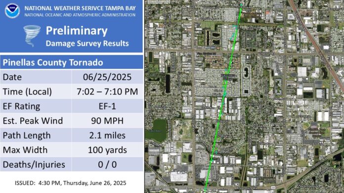
On June 25th, 2025, strong thunderstorms developed over Pinellas County as the east and west coast sea breeze boundaries collided. These thunderstorms were further enhanced by a strong upper-level low over the state, leading to colder and drier air aloft that enhanced the potential for damaging wind gusts and hail. While numerous hail and wind damage reports were received from St. Petersburg to Seminole, a landspout also developed in Largo, FL, along colliding sea breeze and outflow boundaries.
The setup leading to the landspout’s development was complex. Two boundaries collided over Largo—one from a strong cell to the southwest and one from another strong cell to the east. As these boundaries collided, a new updraft began to develop where the collision took place. Strong downdrafts from both cells essentially sandwiched the boundary and the developing updraft between the more mature cells—forcing the developing cell to take a deviant track to the north, right along the boundary collision. This caused the cell to begin rotating.
At approximately 6:57 PM EDT, the TTPA TDWR observed rotation just south of Belcher Rd near the intersection with Bryan Dairy Rd. Reflectivity data at the same time showed almost no precipitation on the 0.3 degree slice, but a still-suspended and developing core aloft at higher tilts. The rotation was not distinguishable on the KTBW radar, given the developing cell’s motion with respect to the beam angle. Ultimately, the angle masked the actual storm-relative velocity. Over the next couple minutes, the rotation intensified and at 7:02 PM, the first damage occurred at a shopping center near the aforementioned intersection. Over the next eight minutes, additional damage reports were received along a track oriented SSW to NNE. The most significant damage was noted in the Ranchero Village community, where several mobile/manufactured structures were badly damaged, indicating a peak intensity of around 90 mph.
At 7:10 PM, the landspout dissipated as the TTPA TDWR data showed the mesocyclone weakening. This took place as a gust front from another mature cell to the east arrived, altering the ability for the developing cell to remain on the boundary that was allowing it to spin. In total, the feature was tracked for just over 2 miles and had a maximum width of 100 yards.
Largo Tornado
• Rating: EF-1
• Estimated Peak Wind: 90 mph
• Path Length: 2.11 miles
• Path Width: 100 yards
• Fatalities: 0
• Injuries: 0
• Start Date: 06/25/2025
• Start Time: 07:02 PM EDT
• Start Location: 3 SE Largo / Pinellas County / FL
• Start Lat/Lon: 27.8715 / -82.7436
• End Date: 06/25/2025
• End Time: 07:10 PM EDT
• End Location: 2 ESE Largo / Pinellas County / FL
• End Lat/Lon: 27.9016 / -82.7369
